Imfarrukh

GIS Expert

Photographer

Chess Player

Imfarrukh

GIS Expert

Photographer

Chess Player

you have to keep breaking your heart until it opens.
Rumi
Rumi
About Me

Hello, I'm Farrukh Zahid, a seasoned Geographic Information Systems (GIS) professional with over a decade of experience leveraging spatial data to drive insightful solutions. My journey in GIS began with a profound curiosity for understanding the world through mapping technology.
Throughout my career, I've been involved in diverse projects spanning urban planning, environmental analysis, and infrastructure development. I excel in using advanced GIS software to uncover valuable patterns in geographic data, helping organizations make well-informed decisions.
I've had the privilege to collaborate with cross-functional teams, bringing my skills in spatial analysis, cartography, and geodatabase management. My passion lies in harnessing GIS technology and effectively communicating complex spatial information to stakeholders in a clear and actionable way.
I'm enthusiastic about the endless possibilities GIS offers in tackling real-world challenges and always keen to explore new ways spatial data can create a meaningful impact.

  • Address: Doha-Qatar
My Services
Decision Making

GIS makes the municipal decision-making process smarter, by putting the power of spatial analysis at your fingertips.

  • Drive economic growth
  • Plan infrastructure improvements
  • Make smart decisions about natural resources
  • Allocate funds, according to need.
  • Build better cities
Site selection

Site selection analysis is used in GIS to select the best location or site for a facility. When performing site selection analysis, travel time information can help us find the locations that are the most reachable, or those that optimise coverage of key services, such as healthcare.

Geo-Marketing

Geo-marketing is a tool that uses geographic, or location-based, information to help companies put together marketing strategies and campaigns. Using digital mapping to organize and display data enables marketers to analyze data by region or a particular physical location (for instance, a store)

Digital Mapping

Digital mapping (also called digital cartography) is the process by which a collection of data is compiled and formatted into a virtual image. The primary function of this technology is to produce maps that give accurate representations of a particular area, detailing major road arteries and other points of interest. The technology also allows the calculation of distances from one place to another.

Fun Facts
Music Yeah
Love Photography Visit my Unsplash page
1 000 Cups Of Tea why not 🙂
Currently playing battelfield V
Professional Journey
Experience
Jan-2023 To Present
Senior GIS Specialist

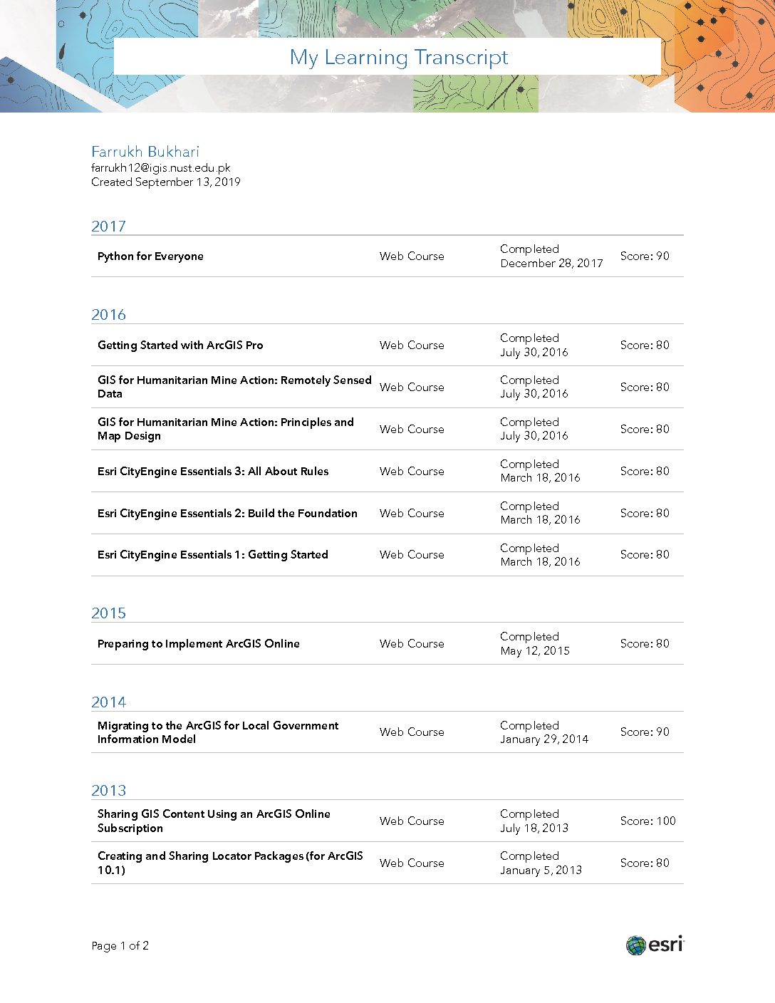
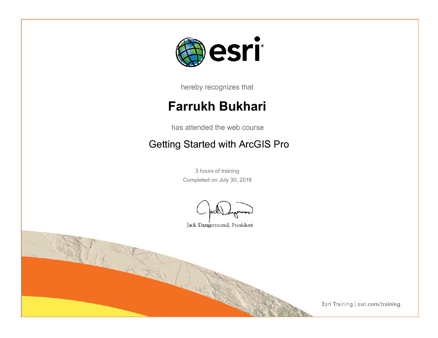
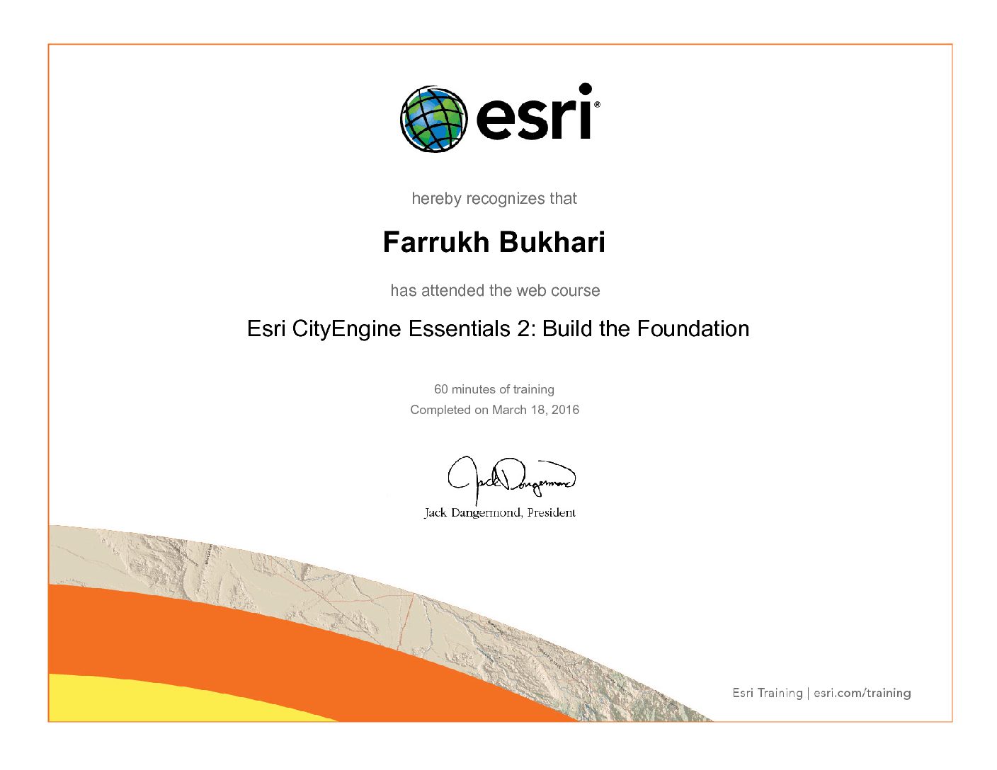
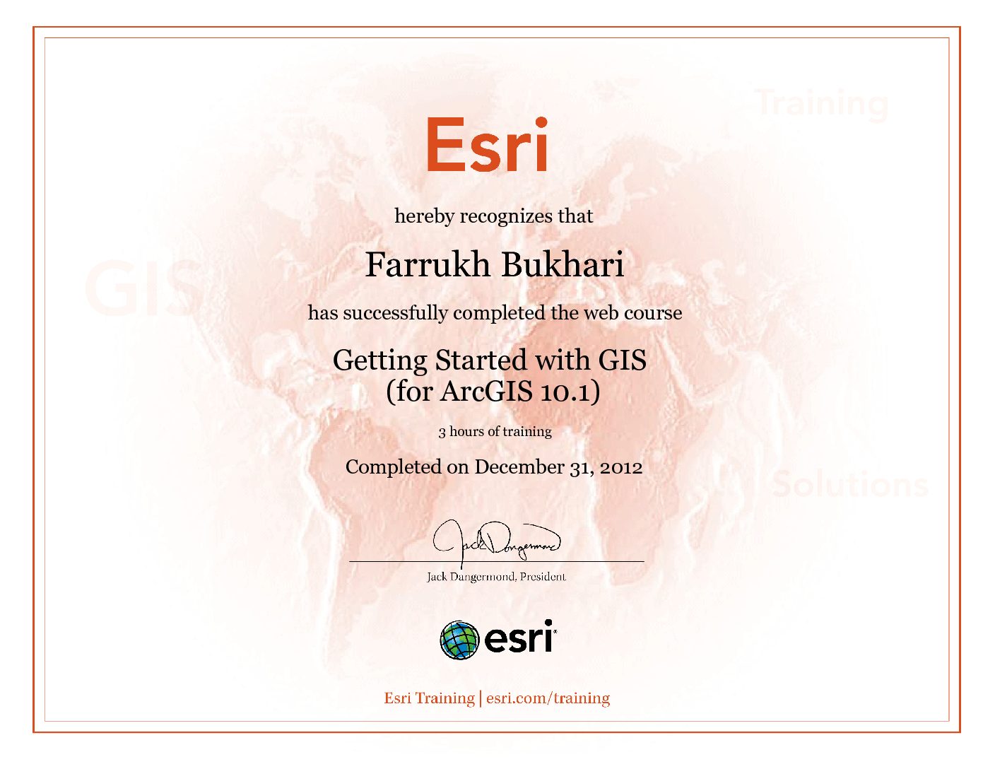
I’m currently engaged in developing applications using ESRI’s Instant Apps and ArcGIS Studio. These applications are designed to facilitate decision-making and provide rapid responses.

  • Digital Twin for Doha city
  • Nearby instant and mobile applications
  • Building an app for 3D GIS
  • 3D Mesh Creation for Different zones
  • Installation of ArcGIS Server on Microsoft Azure virtual machines (VMs).
  • Health Monitoring of GIS Servers (AcrGIS Enterprise)
  • Database Management API’s and Rest Services Management
  • Maintain the Key Components of ARCGIS Enterprise (Portal, Datastore
    and Server)


Jan 2024 to Present
Geographic Information Systems Consultant (Freelance)
Tomkulak, Canada

Suitable Site Selection for Ports in Artic Regions of Canada.

Suitable Site selection for Ports
Analyzing the bathymetric Data
Identification of best suitable tracks for cargo ships
Sea depth monitoring
Shoreline analysis

Nov-2021 - Dec-2022
Geomarketing Specialist-Enterprise Fixed
Enterprise Fixed Geomarketing Du-Edara Dubai, United Arab Emirates.

As an Geomarketing Specialist, I am offering my services for Emirates

  • Integrated Telecommunication (EITC-DU) are highlighted below:
    • Development of Digital Maps
    • Ready-to-use services Data-driven visualization, Data hosting and management
    • Built-in spatial analysis tools
    • Identification of best suitable decision making for business growth based on geographical market analyses.
    • Obtain detailed insights into markets, target groups (Government Key account and SOHO) and potential using regionalized market data such as 2GIS.
    • Visualize large amounts of company and potential data on digital maps and analyze this data using ARCGIS applications.
    • Database management
    • Development of Dashboard ARCGIS Online for:
      • View of geographic information and data like potential sites or existing customers.
        • Status of the buildings either fiber is connected or not
      • Monitoring the events
        • On the base of events like we can provide the service to the new customers or not make decisions, inform others, and see trends.
Feb-2021 to Oct-2021
GIS Planner
Etisalat Dubai, United Arab Emirates.

Planner Etisalat Access Network

  • Telecom operators usually develop business cases for the deployment of high-speed fiber to the home (FTTH) networks, taking into consideration that the major limiting factor is the deployment cost which is mostly related to civil works.
  • Being GIS Planner in Etisalat, my key role is to update the existing Civil & cable network. Major key points are highlighted below.
    • Fixed Network Planning
      • Network Engineer is a telecom extension to industry standard GIS software provided by ESRI. It’s a powerful GIS based software for the planning and maintenance of such large network routes and grids.
        • Civil Route Update
        • JRC/MH and Other Structure Placement
        • Fiber Tracing
        • Connectivity of Fiber with FDH & Splitter
        • Fiber Flow analysis from OLT to end user (Plot)
        • Schematics & Attributes Update
      • Maintenance of Geodatabase
Feb-2020 to Jan-2021
GIS Expert
Circle Engineering Consultancy, Abu Dhabi-UAE.
  • Development of Digital Library for Hydro-geological Mapping of the United Arab Emirates (2020-2023).

  •  The strategic objectives of the project are as follows:

    • Establish a set of comprehensive GIS-Based hydro-geological maps with different scales.

    • Develop Guidelines for the sequence steps and procedures used in developing the UAE Hydro-geological Maps.

    • Enhance the existing geodatabase containing all hydro-geological data and informative layers.

    • Enhanced capacity of the national manpower involved in the field investigation, data interpretation, data verification, hydro geological mapping and information dissemination.

  • Web Based Spatial Data online View Portal.
  • Data Collection and Refinement.
  • Water meters, status mapping for Al Ain & Liwa Regions.
Nov-2016 to Jan-2020
GIS Manager
United Track System, Lahore-Pakistan.
  •  Digital mapping of Pakistan Map for Vehicle Tracking.
  •  Prepares GIS project plans and schedules to include coordinating re-
    sources, tasks, and work assignments
  •  Managing the survey for the collection of landmarks & Landmarks Collection through Open Street Maps (OSM) & Google Api’s.
Oct 2016- Nov 2016
GIS Supervisor
Project Management Unit, Railway, Headquarter, Lahore, Pakistan.

Project: Railway Land Record Management Survey Inspection of Urban Unit Team (Karachi Division)

  • Administration, coordination and managing GIS activities among the divisions of Pakistan Railway, & Landmark analysis with Patwaris (Patel).
Feb 2016 to Sep 2016
GIS Expert
SKAFS Consultant, Lahore-Pakistan.

Project: SAAF PAANI (Package 4 & 8)

  • Ground Water quality maps through Public Health Engineering Department (PHED), surveyed data & Skafs team surveyed data.
  •  Analysis of ground water quality maps of PHED and Skafs surveyed data.
  •  Data collection from the satellite imageries and other sources for the analysis of best site suitability water filtration plant.
  • Survey data evaluation
    w.r.t its defined variables and parameters ranges for interpolation.
March 2015 to Aug 2015
GIS Specialist
Pakistan Industrial Trading Corporation (PITCO), Lahore-Pakistan.
  • Project: Planning And Distribution Program (P&D)-USAID Analysis and interrogation of spatial data from the GIS surveyors team,
    and the extraction of useful information can be presented on the map and visually.
  • Maintain the database with the help of Microsoft Access.
  •  Electric lines, maps created with the data collected from the field surveyors.
  • Meet the electrical engineers for to analyses the electricity loses.
  • Analyze spatial data for geographic statistics to incorporate into documents and reports.
Jan 2015 to Feb 2015
GIS Supervisor
The urban Unit, Lahore, Pakistan.

Project: Federal Government Employment, Housing Foundation (FGEHF)

  • Conducting surveys for the collection of data Research Associate (Part-time)
June 2014 to March 2015
Reserach Assosiate
US-CASEN, NUST Islamabad, Pakistan.

Project: Capacity Building & Strengthening of Biomass Gasification
Technology Support Systems USAID

  • Identification of crop types with the help of SPOT (satellite) images.
  • Estimation of crop residue for the generation of electricity.
  •  Calculating the energy production with residue.
  • Crop types availability, maps making in the Punjab region.
  • Mapping of Crop residue for Punjab region.
Education
2012-2015
National University of Sciences & Technology, (NUST)
Islamabad, Pakistan

Master of Sciences in Remote Sensing & GIS


2005 - 2009
Bsc Hons Computational Physics Center for High Energy Physics, The University of Punjab.
Lahore, Pakistan
2021
Publication

"Wind farms, selection using geospatial technologies and energy generation capacity in
Gwadar"

https://www.sciencedirect.com/science/article/pii/S235248472100768X

Skills
Design
  • Digital Mapping
  • Decision Making
  • Spatial Analysis
  • Data Handling
Languages
  • English
    90%
  • Urdu
    90%
Coding
  • Python
    60%
  • PostgresSQL
    75%
  • Angular / JavaScript
    65%
  • HTML / CSS
    65%
Knowledge
  • Maps Making
  • Decision Making
  • Web Development
  • Site Selection

Certification

Works

ESRI MOOC

  • Make an Impact with Modern Geo Apps
  • Spatial Data Science: The New Frontier in Analytics

Project Management Professional (PMP)

ESRI Ceritifcations

Du Awards

Get in Touch
  • Address: Doha Qatar
  • Email: me@farrukh.me
  • Phone: +974-70110973
  • Freelance: Available
Contact Form